Buffer Strips and Floodbreak Hedges in Lèze Catchment, France
Sponge Scapes case study 03 FR
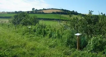
The Lèze is a river located in the South of France, near the Pyrenees, on the French departments Ariège and Haute-Garonne. The case study concerns the implementation of floodbreaking hedges, which are located across the flood plain of the Lèze and are regularly spaced (every 300 to 500 metres). Partially obstructing the flow, such hedges can slow down running water and dissipate its energy. The project has been financed by the SMIVAL (20%), French State, local authorities, ERDF and the Water Agency (80% for all).
SMIVAL, the case owner, is committed to fostering stakeholder dialogue to agree on a sponge strategy at sub-basin scale. Scaling-up to the whole catchment scale will then be considered. The case study thus serves as a SpongeLab, emphasizing participatory processes in the design and evaluation of sponge strategies (combinations of sponge measures at the landscape scale). Workshops will be conducted to generate spatial scenarios and collaboratively assess potential impacts. We will explore combinations of linear and area-based measures to optimize erosion reduction and improve overall landscape resilience.


Overview
The Lèze catchment is located in a hilly pre-mountainous area (Pyrenees), and is part of the larger Garonne catchment. Like most of the rivers in the Pyrenean foothills, the Lèze has very marked seasonal variations in flow. In the upper part of the basin, a large irrigation dam controls the river flow to a large extent. In addition 11 small dams along the river also control the flow to some extent.
Land use has changed in recent times, from traditional cattle and sheep farming on small meadow fields bordered by hedges to large open fields of arale crops. To increase the size of fields, many hedges were destroyed and there has been a significant reduction in the length of hedges in the catchment. The slope, combined with erosion-prone soils, has resulted in increased soil erosion and related problems.
| Authority type | Authority name | Authority role | Comments |
|---|---|---|---|
| Local water authority | SMIVAL (Syndicat Mixte Interdépartemental de la Vallée de la Lèze) | Initiation of the measure | The SMIVAL (Syndicat Mixte Interdépartemental de la Vallée de la Lèze - an association of 24 communes localised in the Lèze's valley) has been created in 2003. It is responsible for leading, for defining and for implementing actions for a qualitative and quantitative use of the Lèze and its tributaries and for preventing its floods. |
| Farmers | Chambres d'agriculture | Determination of design details of the measure | — |
| — | Technical Committee | Implementation | The Technical Committee supervises the implementation of the PAPI. It is presided by a sub-prefect and the president of the SMIVAL. Techical Committee includes the SMIVAL, local authorities, deconcentrate technical state services, public agencies for water management (Onema, Agence de l'eau Adour-Garonne) Chambers of agriculture. |
Site Information
Design and Implementation
- Functionality
- Acceptability
- Information to the public
- Consultation and participation of stakeholders
Finding voluntary farmers and land owners.
Financing
Between 2009 and 2012, 3020 linear metres of hedgerows have been planted (including 520 linear metres for the two test hedgerows) for a total cost of 47 870 € (costs for hedgerows which have been planted later are not taken into account).
Costs are distributed as follow:
- Technical study: 9 240 € in 2007
- First test hedge (in Montaud): 4 221 € in 2008 and 3 532 € in 2009
- Second test hedge (in Artigat): 3 420 € in 2010
- Hedge planting 2011-2012: 27 456 € in 2011 and 2012
Cost of one linear metre of hedge : 11 € as planned by the PAPI. But for the test hedgerows, costs reached 45 to 60 € per linear metre.
This option was never chosen by land owners.
Farmers chose an agreement without any financial compensations (considered as simpler for farmers).
Policy and Governance
Land consolidation in the river basin is the main explanation of the removal of hedges. The change of agricultural machinery enabled/needed larger parcels of land.
The loss of “effective” hedgerows have several direct consequences such as:
- A decrease of the infiltration rate and an increase of the runoff rate;
- A concentration of the runoff and an acceleration of the water flow;
- An increased risk of soil erosion and a more frequent risk of mudslides;
- Higher and faster peak flow of flood events causing damages on human populations and activities.
| Directive | Relevant pressure |
|---|---|
| Floods Directive identified pressure | Other pressure contributing to flooding/flood risk |
| Directive | Relevant impact |
|---|---|
| Floods Directive identified pressure | Economic activity |
| Floods Directive identified pressure | Infrastructure |
| Floods Directive identified pressure | Property |
| Requirement directive |
|---|
| Floods Directive-mitigating Flood Risk |
| Floods Directive-establishing adequate PoM |
The action programme which includes the implementation of floodbreaks is called the PAPI of the Lèze. PAPI means “Programme d’actions de prevention des inondations” (Action Programme for Preventing Floods). At the scale of river basins, PAPIs promote integrated flood prevention.
| Wider plan type | Wider plan focus | Name | Comments |
|---|---|---|---|
| Local | Water | PAPI de la Lèze : Programme d'Actions de prévention contre les inondations de la Lèze (Actions Programme for preventing floods of the Lèze river) | The PAPI is an action programme designed for fighting floods in the Lèze river bassin. Planting floodbreaking hedgerows is one of these actions. The PAPI has been approved by the French Ministry for Ecology, Sustainable Development and Territorial Planning. |
| Activity type | Comments |
|---|---|
| Public meetings | Several public meetings took place from 2009. They aimed at presenting the actions programme (including hedgerows) to the inhabitants. For each meeting, about 20 participants were presents. The SMIVAL also met inhabitants and local associatiations. |
| Meetings with farmers | Numerous meetings took place with farmers and landowners who may be concerned by planting floodbreaking hedges. The main issue was to explain implementation of this action and to define the associated land policy. |
| Consultation with local authorities | In 2009, local authorities (mayors) have been met in order to know about the implementation of the actions programme (including hedges) at the villages' level. Mayors also had the opportunity to express their expectations. |
| Consultation with technicals | The two local Chambers of agriculture are involved in defining the protocole regarding the land policy. Technical partners (for example deconcentrate technical state services and water related public agencies) have been consulted by the SMIVAL when actions of the PAPI have been presented and implemented. |
| Public inquiry | A public inquiry has been carried out in 2011. The response brief has been published in August 2011. |
| Arrangement type | Name | Comments |
|---|---|---|
| Organisational arrangement | Protocol for land policy | Protocol between the SMIVAL and the Chambers of agriculture defining land policy (for example purchase of arable land for hedge planting) Four options are available to farmers: agreement with the SMIVAL, servitude, renting and buying |
| Contractual agreement | Framework agreement | The Framework agreement has been signed in August 2008 by the SMIVAL and its partners (French State, Adour-Garonne Water Agency, Regional council, General councils of Ariège and Haute-Garonne). This Framework agreement works for the implementation of all actions included in the PAPI for the period 2008-2016. |
Impacts and Monitoring
Monitoring System
Maintenance
Impact Assessment Methodology
Socio-economic Impacts
Biophysical impacts: Hydrology
No in-depth hydrological analysis has been carried out in order to assess the impact of floodbreaking hedges on the dynamic of flood events (flood flows, velocity, spread of peak flows, etc.). Moreover, such an analysis his difficult to carry out.
Biophysical impacts: Biodiversity
Biophysical impacts: Water & Soil Quality
Biophysical impacts: Others
Lessons Learned
It is particularly important to involve farmers and land owners as well as the local population in order to make sure than enough voluntaries can be found.
| Driver type | Driver role | Comments |
|---|---|---|
| Past flooding events | Main driver | For example, the involvement of farmers is higher when they see mudslides in their fields than when they hear about slowing down peak flow. |
| Success factor type | Success factor role | Comments |
|---|---|---|
| Attitude of relevant stakeholders | Main factor | An enabling factor for involving local stakeholders is the overlap of global issues and local events. For example, the involvement of farmers is higher when they see mudslides in their fields than when they hear about slowing down the peak flow. |