Restoration of hydrological system in the Middle basin of Biebrza Valley, Poland
The EC LIFE programme’s co-financed project aims to restore the hydrological system in the Middle Basin of the Biebrza Valley to support the conservation of water-dependent habitats and open marshland bird species. It focuses on controlled water management and re-irrigation to halt the degradation of peatlands within the water system of the Rudzki Canal, Ełk River, Jegrznia River, and Woźnawiejski Canal. Key measures include constructing water retention infrastructure to maintain wetland conditions, especially during dry years.
Phase I (LIFE09, completed in 2016) included redirection of water flows, construction of barrages and thresholds, partial riverbed restoration, land acquisition, and mowing of overgrown areas across 9,000 ha. Phase II (LIFE13) is ongoing and expands interventions to an additional 13,452 ha, aiming to further restore wetland hydrology while maintaining agricultural and tourism use.
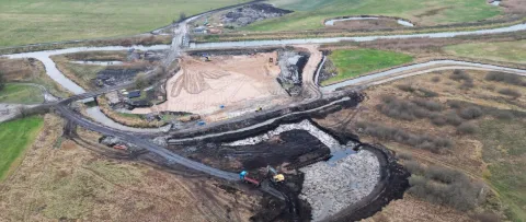
Recent works include the construction of a new hydrological junction at Modzelówka, designed to direct approximately 80% of the Kuwaski Canal's flow toward the Rudzki Canal and 20% to the reactivated Ełk riverbed. In 2023, a high-durability PE-HD siphon system was installed to support this redistribution, designed for minimal ecological impact. These efforts have already shown benefits such as improved groundwater retention, reduced fire risk, and better conditions for both biodiversity and local agriculture. Full implementation of Phase II is expected by 2026–2027.

Overview
2. Redirect water flows to restore wetland water conditions:
In Phase I: divert ~70% of Woźnawiejski Canal water back into the Jegrznia River.
In Phase II: divert ~80% of Kuwaski Canal flow into the Rudzki Canal and 20% into the old Ełk riverbed.
3. Improve conditions for hydrogenic habitats and Natura 2000 wetland species, particularly open marshland birds like the Aquatic Warbler (Acrocephalus paludicola).
4. Reduce peatland degradation, fire risk, and mineralisation by raising and stabilising water tables.
5. Build and modernise water infrastructure: 6 barrages and 1 threshold in Phase I, an hydrotechnical junction and siphon system in Phase II.
6. Mow or clear vegetation on hundreds of hectares of overgrown peatland to maintain open habitats.
7. Increase awareness and cooperation with local stakeholders, including landowners and farmers, through consultation and information campaigns.
| Authority type | Authority name | Authority role | Comments | Authority responsibility |
|---|---|---|---|---|
| Nature park | Biebrza National Park | Other | Project planning and management Construction works and ecological restoration Monitoring and stakeholder coordination | Responsible |
| Regional / sub-national water authority | Regional Water Management Authority (RZGW Białystok) | Determination of design details of the measure | Provided technical input on hydrological infrastructure and canal operation. | Supporting |
| Research institute / University | University of Białystok / Warsaw University of Life Sciences | Monitoring | Participated in ecological monitoring, hydrological modelling, and habitat assessment. | Supporting |
| NGO | NGOs and local stakeholders | Other | Involved in awareness campaigns, consultations with landowners, and promotion of sustainable land use practices. | — |
Site Information
Moss communities (Sphagnum species)
Sedge meadows (Carex species)
Reed beds (Phragmites australis)
Alder and willow shrubs in wetter areas
Design and Implementation
Financing
Phase II (LIFE13) amounted to €6,641,806
Policy and Governance
| Name |
|---|
| Local spatial plan of Goniądz |
| Activity stage | Comments |
|---|---|
| Design phase | To implement the measures, the local spatial plan had to be ammended. Therefore SEA study was implemented, including public consultation. |
Impacts and Monitoring
Monitoring System
Maintenance
Impact Assessment Methodology
Socio-economic Impacts
Fuel Production : Biomass-based OTOPellet (~16 GJ per pellet)
Integration into 2014–2020 Rural Development Programme, securing agri‑environment subsidies
Cultural Preservation : Recognition and use of traditional knowledge in management planning
Biophysical impacts: Hydrology
Biophysical impacts: Biodiversity
Biophysical impacts: Water & Soil Quality
Lessons Learned
The project showed that restoring peatlands requires managing the full water network—rivers, canals, and groundwater—not isolated sections.
Monitoring enables adaptation.
A dense network of piezometers and gauges, linked to a DSS, allowed real-time tracking and flexible, evidence-based management.
Groundwater inflow is essential.
Modeling proved that even small increases in lateral groundwater recharge significantly improve peatland water balance and resilience.
Use of durable, low-impact materials is key.
PE-HD siphons were well suited to wetland conditions—long-lasting, corrosion-resistant, and minimally invasive.
Local economy and ecology can align.
Harvesting biomass for fuel (e.g. OTOPellet) helped manage vegetation, reduce fire risk, and support rural employment.
Land ownership matters.
Access to private land through purchase or agreement was vital to restore hydrological continuity and ecological function.
Restoration supports climate resilience.
Rewetting reduced drought and fire risks, while enhancing biodiversity and buffering climate extremes.
| Driver type | Driver role | Comments |
|---|---|---|
| Legal obligations | Main driver | to protect biodiversity in the Park area |
| Availability of subsidies | Main driver | LIFE+ funding provides co-financing for such activities |
| Success factor type | Success factor role | Comments |
|---|---|---|
| Attitude of relevant stakeholders | Main factor | The project is still in the implementation phase |