
Summary
The intensive urban development of the Bezannes joint development zone (ZAC), near Reims, has led to the artificialization of 172 hectares of land, along with a growing need for stormwater management. Vegetated swales were implemented in the southern part of the area, while in the north, stormwater is collected and directed to a facility that includes an artificial wetland, an artificial lagoon, and a reed bed filter.
The construction of this facility, initiated by the Greater Reims Urban Community (project owner) and Sinbio (project manager), aimed to incorporate a nature-based solution to manage stormwater inflows upstream of the Muire River, improve the quality of discharged water, and create a 5-hectare natural space that would benefit both local residents and biodiversity called Parc de la Roselière.
This project illustrates a shift from traditional civil engineering to ecological engineering, combining water regulation, pollution control, biodiversity enhancement, and public amenities.
Photo gallery
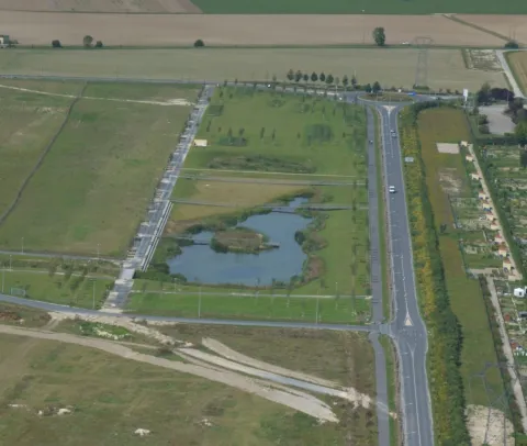


Overview
Prevent downstream flooding and pollution (Muire stream and Vesle river)
Improve stormwater quality through natural filtration
Enhance biodiversity and landscape integration
Provide recreational and educational value via public access
| Authority type | Authority name | Authority role | Comments | Authority responsibility |
|---|---|---|---|---|
| Local water authority | Greater Reims Urban Community | Initiation of the measure | Project owner, financing, management. Operates the site. | Responsible |
| Architects / Engineers | SINBIO | Determination of design details of the measure | Led design evolution to natural wetland | Supporting |
| Architects / Engineers | GUINTOLI | Implementation | Implemented wetland, paths and gabions | Supporting |
| Architects / Engineers | ISS Espaces Verts – Reims branch | Implementation | Basin planting | Supporting |
| Architects / Engineers | EDIVERT | Implementation | Park landscaping | — |
| Architects / Engineers | SCEE | Implementation | Lighting | Supporting |
| Architects / Engineers | ANTEA | Determination of design details of the measure | Contributed to early scenario assessment, initial hydraulic study | Supporting |
Site Information
Design and Implementation
Located in the downstream section of the 172 ha ZAC de Bezannes
Lagoon and filter: ~1.2 ha
Total landscaped park: >1 ha
Passive, gravity-based water routing (no pumping)
Multi-functionality: hydraulic retention, filtration, biodiversity, recreation
Design for 1-year to 100-year stormsIntegration of various depths and habitats (open water, wetlands, dry areas)
Public access with wooden footbridges and interpretive panels
Need to avoid adding pressure to downstream sewer network (limited to 85 L/s).
Financing
Park works: 520,000 €
Fence: 370,000 €
Project management : 280,000 €
All values are without VAT.
Policy and Governance
Limit discharge to 85 L/s
Prevent flooding and protect groundwaterImprove water quality and create a recreational space
High groundwater level
Downstream flood risk (Muire & Vesle)
Chronic urban water pollution (hydrocarbons, heavy metals, road runoff)
Reduction of pollutants via reed bed filtration
Public access and landscape integration
Biodiversity creation and spontaneous species colonisation
Strict pollutant discharge thresholds (e.g. 25 mg/L MES, 5 mg/L hydrocarbons)
Landscaping includes three wooden footbridges and a path along the embankment, allowing for a walk around the basin.
| Activity stage | Activity type | Comments |
|---|---|---|
| Other | Informative signage & bird panels | Explains system & biodiversity |
Impacts and Monitoring
Monitoring System
Maintenance
Impact Assessment Methodology
Socio-economic Impacts
Increased land value and public satisfaction.
Biophysical impacts: Hydrology
Discharge regulated at 85 L/s
Passive gravity-based outflow prevents downstream network saturation
Early limitation: underperformance at start due to incomplete roadworks and insufficient inflow
Biophysical impacts: Biodiversity
Spontaneous colonisation by frogs, fish, and unexpected willow species. Notably, the house martin and the common kestrel - both species in significant decline in recent years - have been observed. Bats (common pipistrelle and the serotine bat), odonates (such as hawker dragonflies and damselflies), orthopterans including the ebony black grasshopper - listed as a regional red list species - and common butterflies like the common blue, marbled white, and cabbage white.
Plantation of 26 wetland plant varieties
Artificial river section: This area hosts the richest biodiversity on the site.
Lagoon section: Ecological diversity and richness are satisfactory, but the planted species are underrepresented. The presence of filamentous algae suggests a meso-eutrophic environment, water renewal is lower than expected.
Reed bed filter section: The plants appear stunted due to insufficient water and nutrients. Eight additional species have colonized the area spontaneously, requiring differentiated mowing management.
Wetland section: Water levels are too low; the planted species are in the minority and have been replaced by plants not typical of wetland environments.
Biophysical impacts: Water & Soil Quality
Treatment of suspended solids, hydrocarbons, and metals
Pollution control compliant with thresholds (e.g. MES < 25 mg/L)
Occasional pollution episodes observed (e.g. sewage backflow, dewatering discharge)
Biophysical impacts: Others
Lessons Learned
Passive, nature-based solutions can replace costly engineered alternatives
Early stakeholder engagement (e.g. landscape architects, ecologists) improves project outcomes
Public accessibility increases acceptance, but requires robust infrastructure
Design flexibility is key to adapting to site constraints (e.g. groundwater)
Anticipating inflow timing and maintenance needs is essential for early functionality
| Driver type | Driver role | Comments |
|---|---|---|
| Organisation committed to it | Main driver | Project director to replace a concrete basin with a natural solution |
| Other | Main driver | Need to manage runoff from a large new urban zone. |
| Legal obligations | Secondary driver | Sustainability ambition embedded in Reims Métropole’s planning policies |
| Success factor type | Success factor role | Comments |
|---|---|---|
| Other | Main factor | Large space available enabled ecological and public integration |
| Existing staff and consultant knowledge | Main factor | Interdisciplinary design team. Combined hydrology, landscape, ecology, and urban design |
| Other | Secondary factor | Public ownership and long-term vision. Enabled consistent management and public park development. |