
Summary
Summary
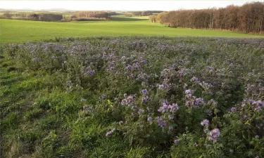
The Schwarzer Schöps case study is located in the East of Germany. The catchment area is about 137 km2, most of which is used as cropland (48%), forest (25%) and grassland (15%). The area is facing an increase in severe floods, soil erosion, and droughts, with negative implications for crop yield stability. In addition, the downstream reservoir Quitzdorf suffers more often from low water tables and high phosphorus pollution which is causing blue-green algae bloom and threatening its multiple services, in particular its important role for nature protection, recreation, and maintaining downstream environmental flows.
Photo gallery


Overview
Year of issue
2025
Project
OPTAIN
Implementation status
Modeled
Contact
Michael Strauch- Helmholtz-Centre for Environmental Research (UFZ)
Location of the project
The Schwarzer Schöps case study is located in the East of Germany.
Saxony/Oberlausitz/Reichenbach OL
Saxony/Oberlausitz/Reichenbach OL
Country
Germany
NUTS2 Code
Dresden
Sponge measures implemented in the case study
Buffer strips and hedges
Filter Strips
Cover crops
Ponds and scrapes
Site Information
Climate Zone
Cool temperate moist
Precipitation
746.00 mm
Temperature (°C)
9.30 °C
Evapotranspiration
585.00 mm
Runoff
161.00 mm
Elevation range
159 - 449 m a.s.l.
Slope range
2 - 10%
Soil type
Luvisols
Stagnosols
Groundwater level
0.4 - 6.7 m
Vegetation class
All potential NSWRM are implemented on cropland. In the model, the vegetation cover changes depending on the type of NSWRM. It changes to permant grassland in case of grassed riparian buffer and grassed waterways, it changes to grass/shrubs/deciduous trees in case of hedges, while for low tillage combined with cover crops there is only a change in crop and soil management (the status quo crop rotation remains the same, but also includes cover crops before corn, spring barley and sugar beet). In case a pond is implemented, arable land changes to a pond. Note: The NSWRM implementation is only simulated.
Design and Implementation
Project scale
Meso
Project scale specifications
Effectiveness of NSWRM for a small river basin
Project area
136 km²
Project area specifications
rural area
Financing
No information provided for this section.
Policy and Governance
Policy description
The river basin has faced increasing numbers of climatic events such as floods and droughts as well as increased soil erosion. This has impacted the quantity and quality of the Quitzdorf reservoir, located at basin outlet. The reservoir is a key water resource for the region and notably Berlin. It is used as a service water supply, for downstream flood protection, to increase downstream flow, as well as for recreation and nature protection. Pollution of the reservoir has resulted in strong eutrophication, blue-green algae blooms, and the poor ecological status of the water body.
The project will be implemented with a variety of stakeholders including: Saxon State Office for Environment, Agriculture and Geology, the State Reservoir Administration of Saxony, the Saxon Farmers’ Association, as well as local farmers and stakeholders implicated in landscape management and conservation.
The project will be implemented with a variety of stakeholders including: Saxon State Office for Environment, Agriculture and Geology, the State Reservoir Administration of Saxony, the Saxon Farmers’ Association, as well as local farmers and stakeholders implicated in landscape management and conservation.
Land ownership
There are 302 potential sites considered for implementing NSWRM in this case study. All are on arable land. Details on the land ownership vary across the potential sites of the NSWRMs.
Policy targets
Runoff control
Peak-flow reduction
Pollutants Removal
Erosion Control
Requirement directive
| Requirement directive | Specification |
|---|---|
| Nitrate Directive (NiD) 91/676/EEC | Nitrates Directive – 91/676/EEC |
| The Birds and Habitat Directives | — |
| Other EU | Sustainable Use of Pesticides Directive – 2009/128/EC |
| Water Framework Directive (WFD) 2000/60/EC | — |
| European Natura 2000 Network | — |
| Common Agriculture Policy | — |
Part of a wider plan
Yes
Wider plan
| Wider plan focus | Name | Comments |
|---|---|---|
| Agriculture | Common Agricultural Policy | The Common Agricultural Policy provides funding for grassed riparian buffers and grassed waterways under Ecoscheme 1a (“non-productive land”). The establishment of hedges is supported by the Free State of Saxony’s regional policy, the Natural Heritage Funding Guideline, although this program is currently inactive. Other measures receive no support or are funded only under specific conditions. |
Public consultation
No
Has contractual arrangements
No
Impacts and Monitoring
Biophysical impacts: Water & Soil Quality
WFD ecological status obj quantity
Schwarzer Schöps: Moderate Reichenbacher Wasser: Poor
Lessons Learned
Drivers
| Comments |
|---|
| Not applicable (OPTAIN is a modelling study, => no single measure has been implemented) |
Success factors
| Comments |
|---|
| Not applicable (OPTAIN is a modelling study, => no single measure has been implemented) |
Sources
No information provided for this section.