
OPTAIN : Upper Zglowiaczka River Basin [Poland]

Summary

Summary

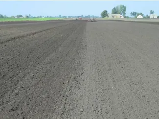
The case study is located in the north central Poland, in Kuyavian-Pomeranian province. The catchment area is about 150 km2. Due to highly fertile soils, arable land prevails (nearly 90%) in the catchment. The main crops are cereals, maize, oilseed rape, sugar beet, alfalfa, vegetables and herbal crops. An area covered by catch crops is increasing. Share of irrigated crops is small. The catchment is coping with an increasing water deficit for crop production and high nitrate loads and concentrations in water. These problems are amplified by low precipitation (annual average equals to 500 mm being the lowest in the country, 300 mm in the growing season) and the extensive drainage system (open ditches and subsurface tiles) that drains water excess in wet periods.The OPTAIN project will support the case study team with identifying and developing efficient land management strategies and small technical solutions to improve the soils’ infiltration and water holding capacities as well as its capacity to filter, buffer and transform pollutants.

Photo gallery
Overview
Year of issue
2025
Project
OPTAIN
Implementation status
Modeled
Contact
Tymoteusz Bolewski and Wiesława Kasperska-Wołowicz, Institute of Technology and Life Sciences (ITP), Poland; Marek Giełczewski, Warsaw University of Life Sciences
Location of the project
Central Poland, Kuyavian-Pomeranian province, Radziejów county (predominantly)
Country
Poland
NUTS2 Code
Kujawsko-Pomorskie
Sponge measures implemented in the case study
Buffer strips and hedges
Subsoiling
Objectives
Potentially: Increase of knowledge and awarness on low water resources and quality problems and  measures possible to implement.
Involved partners
Authority typeAuthority nameAuthority roleComments
Regional / sub-national water authorityState Water Holding- Polish WaterImplementationpotential
NGOwater association of local farmersImplementationpotential
Otherwater law companiesImplementation—
Site Information
Climate Zone
Cool temperate dry
Precipitation
500.00 mm
Temperature (°C)
9.20 °C
Evapotranspiration
620.00 mm
Runoff
50.00 mm
Elevation range
80-120 m a.s.l.
Slope range
flat (0 - 2%) to gentle (3 - 5%)
Soil type
Luvisols
Phaeozems
Groundwater level
Depend on the location: from 1.0 to 3.0 m; average 1.5-2.0 m
Vegetation class
Arable crops (mostly cereals, maize, sugar beet and vegetables)
WFD Ecological status
Moderate
WFD Chemical status
Failing to achieve good
Design and Implementation
Project scale
Meso
Project scale specifications
Meso-scale (catchment scale modelling); micro-scale (field modelling).
Project area
ca. 150 km2
Project area specifications
Rural area
Financing
Financing authorities
Authority nameType of fundingCommentsFinancing share
EU rural development fundsEU-funds: Rural development fundsPotentiallyabout 50%
—National fundsPotentiallyabout 25%
Water associations contributionLocal funds—15%
private- farmer fundsPrivate funds—10%
Policy and Governance
Land ownership
The land is owned mainly by local farmers. The Zlowiaczka river basin is located in central Poland, western of Warsaw. The basin is characterized by a strong agricultural presence, with 90% of the land being arable, and only 4% forested.
Policy targets
Pollutants Removal
Oher Societal Benefits
Erosion Control
Increase Water Storage
Requirement directive
Requirement directiveSpecification
Nitrate Directive (NiD) 91/676/EEC
WFD-achievement of good chemical status—
Part of a wider plan
No
Public consultation
Yes
Consultation activities
Activity stageActivity typeKey issuesComments
Design phaseMARG- Multi-actor reference groupOf the 19 informants interviewed, all agreed that policy mechanisms were not adapted to resolving the environmental and water quantity concerns of stakeholders.Surveys were carried out with stakeholders to better understand barriers and challenges to implementing NWRM in the agricultural sector.
Has contractual arrangements
No
Impacts and Monitoring

Maintenance

Maintenance requirements
Water quality monitoring; Community engagement and education

Biophysical impacts: Water & Soil Quality

WFD ecological status obj quantity
Moderate: Some deviation from natural conditions, but functional. Some water bodies in the catchment are in poor/bad status.
Lessons Learned
Key lessons
Surveys were carried out with stakeholders to better understand barriers and challenges to implementing NWRM in the agricultural sector. Of the 19 informants interviewed, all agreed that policy mechanisms were not adapted to resolving the environmental and water quantity concerns of stakeholders.
Barriers
Barrier typeBarrier roleComments
Lacking financing sourcesMain barrierVoluntary measures oftne not supported by subsidies
OtherMain barrierLand ownership issues, administrative barrieres
OtherMain barrierlow benefit- cost
Drivers
Driver typeDriver roleComments
Availability of subsidiesMain driverSufficient funding
OtherMain driverAwareness of enironmental benefits and protection of soil quality and water resources (quantity and quality) in the region
Sources

No information provided for this section.