
Summary
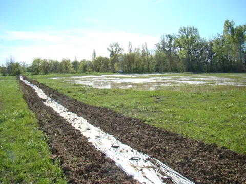
Upstream of L’Isle-Jourdain (Gers), the Save’s active floodplain hosts a complex of wet meadows. To safeguard the downstream drinking-water abstraction, restore wetland habitats and slow floods, the Gascogne Toulousaine community acquired a 13-ha riparian parcel (“Quintarets”), leased it under an agri-environmental contract, converted it to permanent natural grassland using late-cut “hay-flower” transfer, and dug shallow detention basins to retain floodwater and favour wetland plants. Since 2013 the municipality has embedded this action within a wider priority wetland area (~468 ha) and a Departmental Sensitive Natural Area (≈456 ha), with ongoing land purchases and site management led by the SYGESave river syndicate. Technical follow-up (2013–2017) reports rapid grassland naturalisation after hay transfer and longer water residence in the excavated basins. A major update is the June 2022 biotope protection order (APPB) for Bellevalia romana, which secures >22 ha within the L’Isle-Jourdain wetland. Overall, the Quintarets restoration is now part of multi-year catchment management that couples biodiversity protection, drinking-water safety, flood attenuation and public awareness.
Photo gallery
Overview
| Authority name | Authority role | Authority responsibility |
|---|---|---|
| Communauté de Communes de la Gascogne Toulousaine (CCGT) (federation of municipalities of the Gascogne Toulousaine) | Initiation of the measure | Responsible |
| Association de Développement, d'Aménagement et de Services en Environnement et en Agriculture (ADASEA) du Gers (association for development, planning and services in environment and agriculture) | Implementation | Supporting |
Site Information
Design and Implementation
Financing
Policy and Governance
The area is flooded regularly, and is totally submerged every 5 years on average.
Increase the storage capacity of a flood expansion area.
Promote the typical biodiversity of wet grasslands.
Preserve the quality of the living environment and landscape.
Impacts and Monitoring
Monitoring System
the ADASEA du Gers monitors flood episodes by establishing a register of floods and recording area submersed, noting the duration of the flood, submersion extension and nature of the submerged areas with the associated water levels.
Floral monitoring.
Floral monitoring is carried out each year by the national botanical conservatory of Midi-Pyrénées to watch the meadow's evolution.
Impact Assessment Methodology
Floral monitoring
Biophysical impacts: Hydrology
Biophysical impacts: Biodiversity
Monitoring shows the evolution of plant communities towards natural grassland species. Ryegrass dominated regrowth in 2014, before declining sharply the following year to make way for natural grassland species. As at Spring 2018, the floristic composition is thus close to a natural meadow.
The flora that has developed is mesophilic, even in the detention ponds. This may be due to relatively dry years after planting, particularly 2016 and 2017.
As of 2024, the vegetation dynamics are gradually evolving towards a wetland habitat.
Lessons Learned
As of 2024, The natural water retention measures are still functional, but they are less effective than expected due to the site's configuration and the layout of the retention basins. The basins mainly fill up when water flows in from the upstream watershed, rather than from river flooding, as the river is flanked by levees that limit overflow. They also dry out too quickly, as the water drains away through a ditch that was unfortunately left in place during the works, at the request of the project owner. New adjustments are currently being considered. On a more positive note, the vegetation dynamics within the basins and the plot, which are being monitored regularly, are promising and are gradually evolving toward a wetland habitat.
| Driver type | Driver role | Comments |
|---|---|---|
| Availability of subsidies | Secondary driver | The water agency and FEDER subsidies allowed mobilise all actors necessary for the project. |
| Past flooding events | Main driver | A wetland already recognised in the surrounding, an abstraction well sensitive to diffuse pollution, and the risk associated with the downstream urban area sensitive to flooding (floodable) |
| Success factor type | Success factor role | Comments |
|---|---|---|
| Existing regulations | Main factor | Biotope protection order (APPB) for Bellevalia romana |