
Summary
South of Bratislava, the Morava River and its tributaries were modified at three sites to restore wetland biotic complexes and enable movements between habitat fragments isolated by land use. Under the Biodiversity Protection Project (GEF/World Bank with national funds), four oxbows and over 19 km of floodplain were restored.
Building on this, Slovakia is implementing a new, larger restoration phase funded by the national Recovery and Resilience Plan. The state water manager (SVP) is restoring a 17-km section of the Morava (river km 69–51.9) across the cadastres of Sekule, Moravský Svätý Ján, Malé Leváre, Veľké Leváre and Gajary, based on a VÚVH study (2021). Planned measures include reconnection of side arms/oxbows, local bank lowering/softening, selective removal of bank protection and targeted re-meandering with natural materials to improve floodplain inundation, groundwater storage, water quality and ecological connectivity. Completion is currently targeted for June 2026.
Photo gallery
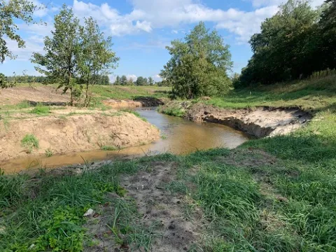
Overview
On the Morava, the works targeted partial restoration of side-arms; the case records 4 oxbows and >19 km of floodplain restored. (These figures describe the intended/achieved scope of that phase.)
- reconnect cut-off meanders/side arms
- remove bank revetments to trigger natural lateral dynamics
- locally lower natural levees to increase frequency/duration of floodplain inundation
- optimise the scheme to respect Q100 flood-protection levels, ice regime, and habitat diversity
The active project aims to restore ~17 km of the Morava by reconnecting side arms/oxbows, restoring floodplain inundation and river processes, to improve groundwater storage/quality and ecological status/connectivity; works also entail large-scale earthworks (~360,000 m³).
| Authority type | Authority name | Authority role |
|---|---|---|
| National water authority | Department of Nature and Lndscape Conservation; Ministry of Environment | Initiation of the measure |
| National water authority | Czech Republic Authority | — |
| National water authority | Austrian Auhority | — |
| NGO | WWF | — |
Site Information
Design and Implementation
Financing
Restoration-Morava: 256000USD --> 187972 €
Policy and Governance
The floodplain forests have been reduce. the water table has dropped and spring floods have been interrupted. Large areas of meadow were ploughed up and converted in to arable fields. the once continuous flood plain area has been transformed into a mosaic of remnant natural areas and areas of intensive management.
| Activity stage | Activity type | Comments |
|---|---|---|
| Design phase | Workshops | in the slovak Republic with management and research personnel and the Slovak ministry of environment Department of Nature and Landscape conservation. Designed to provide key interventios and develop institutional capacieities and the focus of activity will be on three areas. |
| Arrangement type | Name | Comments |
|---|---|---|
| Contractual agreement | GLOBAL ENVIRONMENT TRUST FUND GRANT AGREEMENT | between Slovak Republic (the Recipient) and International Bank for Reconstruction and Development |
Impacts and Monitoring
Monitoring System
Maintenance
Socio-economic Impacts
The project complements other activities such a Bank-financed forestry development loan and GEF-supported protection activities. Components of the project are also directed to integrating planning outside the strictly protected areas in consultation with affected communities and interests.
Employment / social inclusion (SK, 2025): >130 people from social enterprises are employed alongside SVP crews (clearing woody growth, improving meander through-flow). Government notes the aim is to integrate disadvantaged job-seekers and improve regional living conditions.
Land administration (SK, 2025): SVP reports ~90% of land arrangements concluded in the project area; expropriation notices state the works should not prevent continued use of remaining parcels. (Administrative/social dimension of delivery.)
Public outreach & cross-border exchange (SK–AT, 2023): INTERREG Kli-Ma project held public events and education for children/general public on Morava water-level optimisation and climate adaptation.
Agriculture & rural income (SK, Ramsar case): programme to convert ~150 ha to species-rich meadows and support management of ~1,000 ha via direct farmer subsidies; anticipated outcomes include higher hay production improving owners’ income, benefits for hunting/fishing associations, and more tourism.
Biophysical impacts: Hydrology
Long-term groundwater level declined ~0.9–1.2 m (1958–1994) in the central/upper border reach, linked to bed incision and regulation (context, not a measured effect of the 1990s works). Danube backwater can reach ~23 km upstream, influencing levels.
Current RRF project (r.km 69–52): aims to restore floodplain inundation, groundwater storage and water quality via side-arm reconnections and bank lowering; no published post-work impact data yet (works ongoing to 2026).
Biophysical impacts: Biodiversity
Biophysical impacts: Water & Soil Quality
Biophysical impacts: Others
Lessons Learned
Early oxbow reconnections (1990s) showed that design choices matter: rock-weir intakes created low velocities, high sediment inputs and rapid blockage of meander entrances. Nine years of eco-hydromorphological monitoring concluded the benefits were short-lived and conditions worsened without sufficient flow dynamics.
From this, practitioners derived clear technical lessons: analyse present river processes before acting; evaluate effects on flow and sediment transport with models; and avoid copy-pasting measures to dissimilar rivers. Alternatives such as full meander integration were proposed to restore dynamics; lower-outlet reconnection alone would need continuous maintenance.
Later project phases reflect that learning: the current 17-km restoration is based on Water Research Institute (VÚVH) studies and numerical/physical modelling (“Plan of measures… km 69–51.9, Variant 2, 2021”), in line with national restoration guidance published by VÚVH/MŽP SR.
Finally, the river is transboundary. Results and acceptance improve when actions align across the corridor: Austrian LIFE works on the Lower Morava reconnected multiple side arms and islands, illustrating the benefit of coordinated, reach-scale planning on both banks.
| Driver type | Driver role |
|---|---|
| Organisation committed to it | Main driver |
| Success factor type | Success factor role | Comments |
|---|---|---|
| Attitude of decision makers | Secondary factor | Qualified and very committed professionals within the PMCU |
| Existing staff and consultant knowledge | Secondary factor | Establishment of the Joint Scientific Advisory committes proved usefull for provideing guidance to the project activities and specially for increasing awareness of the project among the national and international scientific and academic community. |