
Résumé
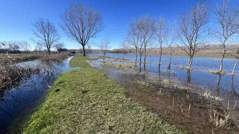
The fragments of floodplain forests (Fraxino - pannonicae -Ulmetum) along the River Körös were cut from the river by dykes during the river regulation works in the 19th century. The deteriorated groundwater conditions were worsened in a drought period during the 1980-1990’s that triggered action of the forestry service. Restoration of the river connection and the floodplain watercourse network provide surface water supply from the backwater of flood waves to the 2000 ha forest. The result of the habitat reconstruction work is a 38.8 km long water-flow and a water surface of 15.7 hectares, cc 400 hectares of the forest has a direct positive ecological impact.
The water supply of the floodplain channel network has another source as well. A smaller volume comes from a fishery. In case of this second source the nutrient content of the fishery is assimilated in the forest as an additional service. Previously this load were let back into the river directly.
Due to the particularly dry recent years, there has been an increase in the tendency to retain water in the watershed. Landowners have voluntarily offered areas designated for periodic flooding in order to mitigate the damage caused by drought during summer periods. Due to the water shortages, the use of water retention options has become more valuable. For this reason, in 2025 temporary storage is carried out at two locations along the canal.
Photo gallery


Vue d'ensemble
Regulation of the chemical status of freshwater.
Enhance infiltration into the soil at the detention ponds to recharge subsurface resources.
| Authority type | Authority name | Authority role | Comments | Authority responsibility |
|---|---|---|---|---|
| Regional / sub-national water authority | Közép-Tisza-vidéki Vízügyi Igazgatóság | Initiation of the measure | The provider of the public water management services of the area by law. Details that belong to the design of the dyke crossing of the water supply channels. It also has role in the operation of the locks. | Responsible |
| Local water authority | Local governments of the area | Other | Help public acceptance, scenic fit | Supporting |
| Nature park | Duna-Ipoly National Park | Determination of design details of the measure | Advice on ecology questions | Supporting |
| NGO | Water Management Association South Pest County | Implementation | Representative of farmers interest towards the water services | Supporting |
Site Information
Design and Implementation
Keep in mind the social rationality of protection against water logging in areas where drainage cost more than the yield of farming the land use change should promote.
Surplus water that pose threat to life and property must be drained. Residential and agricultural water management must be harmonized and surface water runoff must be reduced by retention and storage.
Conditions that are necessary to reach the good ecological status of water must be provided, especially for the quality of the retained water.
The landscape relief that has the former river branches in the territory
Financing
Policy and Governance
| Directive | Relevant pressure |
|---|---|
| WFD identified pressure | 4.1.2 Physical alteration of channel/bed/riparian area/shore of water body for agriculture |
| WFD identified pressure | 1.3 Point - IED plants |
| Floods Directive identified pressure | Other FD pressure: water logging on agricultural land and urban sites |
| Directive | Relevant impact |
|---|---|
| WFD identified pressure | Nutrient pollution |
| WFD identified pressure | Altered habitat due to hydrological changes |
| WFD identified pressure | Altered habitat due to morphological changes |
| Requirement directive | Specification |
|---|---|
| WFD-achievement of good chemical status | High nutrient and salinity level, dissolved oxygen status medium, not fulfills the requirements of good potential. |
| WFD-achievement of good ecological status | Hydro-morphological status. No zoning, lack of morphological variability along the water course. |
| Activity stage | Activity type | Comments |
|---|---|---|
| Design phase | There were consultation with the private land owners of the area | There were no details provided |
Impacts and Monitoring
Monitoring System
Maintenance
Impact Assessment Methodology
Socio-economic Impacts
Amenity benefits in the settlement where a new 4 hectare park was created above the track of the culvert.
Wildlife management, the area provides higher animal carrying capacity.
Assimilation of nutrient load of incoming water.
Biophysical impacts: Hydrology
Biophysical impacts: Biodiversity
Biophysical impacts: Water & Soil Quality
Biophysical impacts: Others
Lessons Learned
The key difference of this application compared to an area with generally the same problems is the possibility to sort out the transaction costs that emerge from in an area with multi-party ownership.
If the suitable complex knowledge happens to be at the right place, no further incentive is needed to take advantage of an upcoming possibility. †“ It highlights the fundamental need of education about the complex nature of the water-land use-ecosystem nexus.
| Driver type | Driver role | Comments |
|---|---|---|
| Organisation committed to it | Main driver | Enabling factor was the initiative role of the water directorate and its co-operation with the national park to. The main enabling factor was the availability of funds that make possible to tackle problems that the settlement faced. |
| Success factor type | Success factor role | Comments |
|---|---|---|
| Attitude of relevant stakeholders | Main factor | The main success factor was the forestry management's unequivocal understanding of the structural problem what threatens the sustainable operation: the lack of inundations. They grasped the first occasion to finance and negotiate such a development. The financial consolidation/restructuring process of the state forestry organizations provided financial sources that were used to improve fundamental production conditions. |