
Leidsche Rijn sustainable urban development, Netherlands

Résumé

Summary

Leidsche Rijn is no longer only “under development”: the VINEX new town has largely been delivered (c. 1997–2025; ~30,000 homes). The original ambition was to retain stormwater on site, minimise imports of poor-quality water, and use extensive SuDS. It has been realised as a near-closed urban water system. Rainwater is stored and infiltrated via wadis/bioswales, canals and ponds; the Haarrijnseplas functions as the seasonal buffer and as a public bathing lake. The system is actively managed by water authority HDSR through circulation and level control with large pumping stations (e.g., Vleuterweide and Terwijde; Vleuterweide’s two pumps move ~107 m³/min). Utrecht has tightened rainwater policy, prioritising reuse → retention/infiltration → discharge and incentivising disconnection from sewers. Routine monitoring now covers wadi performance (annual coring for 10–15 pollutants and renewal of the top layer when saturated); vertical sand/reed filters are used to polish water before inflow to Haarrijnseplas. Recreation and ecology remain integral, with recent seasons reporting good bathing-water status.

Photo gallery
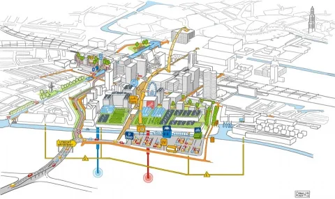
Vue d'ensemble
Year of issue
2025
Project
NWRM
Implementation status
Completed
Contact
Heather Williams and Dilian Jansen, AMEC
Location of the project
The site, Leidsche Rijn, is located on the outskirts of Utrecht, in the Netherlands.
Country
Netherlands
NUTS2 Code
Utrecht
Sponge measures implemented in the case study
Basins
Ponds and scrapes
Swales
Permeable surfaces
Filter Strips
Soakaways
Objectives
The project aimed to create a climate-resilient urban water system by capturing and purifying rainwater locally, reducing runoff, enhancing biodiversity, improving water quality (Less than 0,15 mg/L P (phosphate) in watersystem), and providing recreational and ecological value. It integrates water into urban life as a visible and functional element.
Involved partners
Authority typeAuthority nameAuthority roleCommentsAuthority responsibility
Local water authorityHDSRMonitoringWater authority Hoogheemraadschap De Stichtse RijnlandenResponsible
OtherGemeente UtrechtImplementationCommunal authority responsible for collection of storm water and other urban water in Vleuten-De Meern districtResponsible
OtherGemeente Vleuten-De MeernImplementationCommunal authority responsible for collection of storm water and other urban water in Vleuten-De Meern districtSupporting
Regional / sub-national water authorityProvincie UtrechtMonitoringRegional authority (Province) responsible for natura 2000 and spatial planningSupporting
Site Information
Climate Zone
Cool temperate moist
Precipitation
850.00 mm
Temperature (°C)
10.00 °C
Runoff
765.00 mm
Runoff coefficient
0.90
Elevation range
1 m
Slope range
1-2%
Groundwater level
-1,75
Vegetation class
Urban green matrix with grassed bioswales (wadi’s), nature-friendly banks and emergent macrophytes (notably reeds in the helophyte filter), plus parkland trees/meadows in Máximapark and edible landscape plantings in Rijnvliet.
WFD Ecological status
Moderate
WFD Chemical status
Failing to achieve good
Water quality status
Historic signals: specific pollutants (ammonium, copper) in the Leidsche Rijn water body; summer risks of cyanobacteria/botulism in regional open waters; active provincial bathing-water monitoring at Haarrijnse Plas.
Design and Implementation
Project scale
Meso
Project scale specifications
Leidsche Rijn is one of the Netherlands’ largest urban expansions.
Project area
2400
Size
146.00
Size unit
ha
Basis of design
2-year storm
Principles
Closed/near-closed urban water cycle to minimize imports/exports; widespread SuDS (roofs→streets→wadi infiltration), nature-friendly banks, and a vertical-flow reedbed (helophyte) filter for polishing; operational recirculation via major pump stations; dynamic water-level management for buffering. Indicative capacities: water-level fluctuation designed at ~0.30 m; pump station Vleuterweide 2 pumps, total 107 m³/min; design documentation refers to handling “extreme rainfall” and phased control of stuwen (weirs).
Constraints
Life-threatening incident: cross-connection contamination in 2002 led to gastroenteritis and abandonment of the dual-pipe potable/non-potable water system
Favourable preconditions
VINEX designation (planned large-scale housing development) allowed coordinated infrastructural integration.
Relatively flat terrain with shallow groundwater (~–1.75 m) and gentle slope helped infiltration design.
Existing canal and Lek water source supported testing of dual/third-pipe and reed-bed systems .Support from EU (LIFE+ funds) and locality helped financing and knowledge transfer.
Financing
Total cost
4000000.00 €
Total cost information
Costs of the water management aspects of the project not quantified (incorporated with overall development)
Costs investment information
Costs of the water management aspects of the project not quantified (incorporated with overall development)
Costs operation maintenance information
Costs of the water management aspects of the project not quantified (incorporated with overall development)
Financing authorities
Authority nameType of fundingComments
European UnionEU-funds: LIFE+pilot study in 2009 through LIFE
—Local fundsbudget of local authorities
Policy and Governance
Policy description
By keeping storm water in the Lijdsche Rijn area (through storage and infiltration), the communal waste water sytem and treatmentplant will be relieved. Emissions to surface water will be reduced.
Land ownership
Municipality of Utrecht held/assembled most development land (esp. Leidsche Rijn Centrum) and leased/sold plots; water assets are operated by water authority HDSR.
Policy targets
Groundwater Recharge
Runoff control
Peak-flow reduction
Pollutants Removal
Part of a wider plan
Oui
Wider plan
Wider plan typeWider plan focusNameComments
LocalUrbanMasterplan Leidsche RijnComplete urban development project of the site.
Public consultation
Non
Has contractual arrangements
Non
Impacts and Monitoring

Monitoring System

Monitoring parameters
Annual performance sampling under the NetworkNature plan :
Wide Infiltration Trenches (Wadi) soils are tested yearly (10–15 pollutants, including heavy metals)
Wadis are topped up or partly replaced based on results

Vertical reed-bed (LIFE VERBAL) monitoring:
Includes continuous pH, oxygen, and transparency measurements.
Regular sampling of nitrates, phosphates.
Two-year pilot simulated an accelerated 30‑year lifespan and consistently reduced effluent phosphate to below 0.05 mg/l

Maintenance

Maintenance requirements
General maintenance is overseen by HDSR (region), the municipality, and coordinated via multi-annual plans

Impact Assessment Methodology

Performance impact assessment method
Unknown

Socio-economic Impacts

Direct benefits information
Reduced requirements for sewer system and waste water treatment capacity.
Public health : clean drinking water sourced (~5 M m³/year) via deep groundwater wells.
Social engagement: community rules reinforce stewardship and prevent pollution; pump stations maintain aesthetics and prevent mosquitoes.
Ancillary benefits information
Potential for recreational activities in the water courses that will be created (e.g. canoeing, plazas, ice-skating)
Information on ecosystem impact, reduced energy use
Reduced reliance on pumped drainage lowers energy consumption.

Biophysical impacts: Hydrology

Hydrological effects
The system retains 2.2 million m³ rainwater yearly, reduces peak runoff, increases infiltration and groundwater recharge, and minimizes external inputs. Dynamic water levels and swales prevent flooding and stagnation.
Retained water
2200000.00
Retained water unit
m3/year
Information on retained water
Shift from sewer-conveyance to on-site retention/infiltration; reduced dependency on Amsterdam-Rhine Canal inputs; dual recirculating loops with managed ~0.30 m level variation for storage; major pumps (e.g., 107 m³/min Vleuterweide) move water between sub-catchments; creation of buffer lake (Haarrijnse Plas).
Increased water storage
1000.00
Increased water storage unit
m3/ha
Information on increased water storage
Reduced extreme water levels by ≈35 cm; during high flows ~⅓ of discharge is routed via the Spiegelwaal; overtopping threshold provides controlled activation; creation of a new island and low-flow habitats altered local hydromorphology.
Ecosystem water supply
1
Information on ecosystem water supply
Increased infiltration to groundwater

Biophysical impacts: Biodiversity

Improved biodiversity
Oui
Information on improved biodiversity
In the scheme as a whole, many new water features, including channels and lakes, are created to provide maximum biodiversity opportinites, taking account of the requirements of target species.

Numerous new water bodies with nature-friendly banks and fish passages support aquatic and riparian habitat diversity. Water transparency (~1 m+) enhances ecological conditions.

Biophysical impacts: Water & Soil Quality

Water quality overall improvements
Positive impact-WQ improvement
Information on water quality overall
A test vertical infiltration reedbed was installed at the site, with larger reedbeds now being installed as part of the main development. Improvements to water quality were seen from the test reedbed.
Water quality improvements - Phosphorus (P)
80.00
Water quality improvements - Phosphorus (P) - Unit
% reduction pf pollutant
Information on water quality improvements (P)
80% reduction in P seen from the test reedbed.
Water quality improvements - Total Suspended Solid (TSS)
50.00
Water quality improvements - Total Suspended Solid (TSS) - Unit
% reduction pf pollutant
Information on water quality improvements (TSS)
50% reduction in TSS seen from the test reedbed.
Soil quality overall improvements
N/A info
Information on soil quality overall improvements
N/A info

Biophysical impacts: Others

Ecosystem impact climate regulation
Reduced energy use (farm operations)
Information on ecosystem impact climate regulation
In overall scheme, there will be a probable reduction in pumping requirements compared to the existing agricultural water management system. Green corridors and water bodies provide microclimate cooling and urban heat mitigation.
Lessons Learned
Key lessons
Integration of water retention measure in a developing area is only possible in coordination with many parties, in particular to achieve the ambitious goal of an independently operating (self-sustaining) water system. The water system was designed as an integral part of the overall masterplan, and was considered from a very early stage in development.
Although original implementation aimed for completion by 2017, delays extended development into the 2020s. Ongoing monitoring confirms that sponge measures remain functional and effective.
Barriers
Barrier typeBarrier roleComments
Lacking coordination between authoritiesSecondary barrierA lot of authorities are involved, over a long time period
Lacking financing sourcesSecondary barrierDelays to implementation of the entire residential development have occurred as a result of the economic climate
Drivers
Driver typeDriver roleComments
Balancing different objectivesMain driverDevelopment of a sustainable water system with recreation and ecological goals
Success factors
Success factor typeSuccess factor roleComments
Attitude of relevant stakeholdersMain factorThere should be a shared desire to create a sustainable water system in an area to be developed
Cost effectiveness
Reed-bed systems are likely cost-effective where land prices are high. Figures on entire SuDS cost vs. traditional drainage aren’t published.
Transferability
A general design model emerged from LIFE VERBAL, enabling dimensions, equipment needs, maintenance schedules, and cost estimates applicable elsewhere. Comparable initiatives (e.g., Milan sponge cities, Tilburg Wetlands4Cities) show uptake potential across EU contexts. However, the transferability depends on suitable hydrogeological conditions (flat terrain, shallow groundwater), so site-specific analysis is critical .
Sources