OPTAIN: Dotnuvélè River Basin [Lithuania]

Year of issue
2025
Summary

Dotnuvėlė river basin covers 192.7 km2. Four reservoirs are situated in the area: near Mantviliškis, Akademija, Dotnuva and near Kėdainiai. The Dotnuvėlė basin is in the Central Lowlands of Lithuania, which is rich in moist soils. Agricultural areas account for 69.2%, forests and other natural areas for 24.5%, artificial surfaces - 5.8%, and water bodies make up only 0.5%. State river monitoring is carried out for this river. The ecological status of the Dotnuvėlė river corresponds to poor (upstream) and medium (downstream) classes.

The OPTAIN project will support the case study team with identifying and developing efficient land management strategies and small technical solutions to improve the soils’ infiltration and water holding capacities as well as its capacity to filter, buffer and transform pollutants.
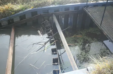
Photo Gallery
Location
55.519442, 23.800036
Project
OPTAIN
National ID
LT_01
Sector
Agriculture
Installation Date
2015
Implementation status
Completed
Contact
Klaipeda University-Natalja Čerkasova, natalja.cerkasova@ku.lt

Overview

Location of the project
Dotnuva
Country
Lithuania
NUTS2 Code
Lietuvos Vidurio ir Vakarų regionas
Objectives
The installation of this wetland contributes to reducing the ecological debt to nature by restoring natural complexes, reaching a balance between environmental and economic interests, and promoting sustainable farming conditions in one of the most important and valuable natural areas of central Lithuania.
Involved partners
Authority type Authority name Authority role Comments Authority responsibility
Architects / Engineers UAB "Aplinkos inžinierių grupė" Determination of design details of the measure Under supervision of Environmental Protection Agency at the Ministry of Environment Responsible
Other Environmental Protection Agency at the Ministry of Environment Implementation — Responsible
Architects / Engineers UAB "Aplinkos inžinierių grupė" Monitoring The project team UAB "Aplinkos inžinierių grupė" is responsible for maintenance during the project period. Afterward, local farmers or community members will take over. —

Site Information

Climate Zone
Cool temperate moist
Precipitation
615.00 mm
Temperature (°C)
9.00 °C
Evapotranspiration
396.00 mm
Runoff
0.72 mm
Elevation range
22-124
Slope range
Flat (0 -2%)
Soil type
Gleysols
Vegetation class
Cultivated cropland, grass turf, forests
WFD Ecological status
Moderate
WFD Chemical status
Unknown

Design and Implementation

Project scale
Micro
Project scale specifications
In the lower part of the river Stabė, 1.8 km from its mouth, a wetland of 2.38 ha has been installed.
Project area
192.7 km²
Project area specifications
urban, rural, wetlands, agricultural, forests
Size
2.38
Size unit
ha
Basis of design
The wetland was constructed by artificially flooding the valley. Corrugated metal plating was used at the inlet and outlet of the wetland to protect the stream banks.
Design capacity
The wetland has four main sections. The deepest part covers 0.21 ha and is up to 2.0 m deep. Sediments are deposited here.

Financing

Total cost
89591.00 €
Costs operation maintenance information
Since the wetland was established form the project funds, the project team UAB "Aplinkos inžinierių grupė" is responsible for the maintenance of the wetland until the end of the project. After the end of the contract - the successor or authorized person of its results, local farmers or members of rural communities will be responsible for the maintenance of wetland. Land user has no maintenance costs and had no establishment costs. The implementation of the project is therefore considered to be positive in terms of cost efficiency.
Administrative costs
5000.00 €
Administrative annual cost information
Since the wetland was established form the project funds, the project team UAB "Aplinkos inžinierių grupė" is responsible for the maintenance of the wetland until the end of the project. After the end of the contract - the successor or authorized person of its results, local farmers or members of rural communities will be responsible for the maintenance of wetland.
Financing authorities
Authority name Type of funding Comments Financing share
European Environment Agency Other EEA grant 100%

Policy and Governance

Land ownership
The land is owned by the family farm. All the agreements were prepared with the supervision of the Enviromnetal Protection Agency. The project for the cuntructed wetland was prepared by the private company.
Policy targets
Pollutants Removal
Target remarks
Reduce nutrient pollution (particularly nitrogen and phosphorus) from agricultural runoff in alignment with EU Water Framework Directive.
Requirement directive
Requirement directive Specification
Water Framework Directive (WFD) 2000/60/EC —
Nitrate Directive (NiD) 91/676/EEC —
The Birds and Habitat Directives Habitats Directive 92/43/EEC
Floods Directive-mitigating Flood Risk —
Part of a wider plan
Yes
Wider plan
Wider plan type Wider plan focus Name Comments
Catchment-based Water EU Water Framework Directive The artificial wetland in the Dotnuvelė River basin is part of a catchment-scale effort to reduce nutrient pollution from agricultural runoff and improve water quality in alignment with the EU Water Framework Directive.
Public consultation
No
Has contractual arrangements
No

Impacts and Monitoring

Monitoring System

Monitoring requirements
The land user incurs no maintenance or setup costs, making the project cost-efficient.
Presence of formal monitoring system
Yes, reports
Downstream station
The wetland was designed to retain nutrients in the spring and reduce their concentrations downstream. Through an ongoing research programme, the impact of the wetland has been monitored from the start. In the first year, vegetation had not become established so there were no impacts. However in 2020 and 2021 there were very positive results in terms of nutrient capture.

Maintenance

Maintenance requirements
The maintenance activities depend and differ on the year. Not every year there is a need to remove sediments or excessed plants. Sometimes there is a need of reintegration or replacement of plant material, especially after winter.

Lessons Learned

Barriers
Barrier type Barrier role Comments
Attitude of relevant stakeholders Main barrier Land availability and willingness
Lacking financing sources Main barrier Lack of long-term funding
Expected maintenance needs Main barrier uncertain responsibility post-project
Drivers
Driver type Driver role Comments
Balancing different objectives Main driver Nutrient pollution reduction needs, water quality improvement goals
Success factors
Success factor type Success factor role Comments
Attitude of relevant stakeholders Main factor Stakeholder engagement 
Other Main factor Tailored design
Available support tools Main factor External funding and support 
Cost effectiveness
Land user has no maintenance costs and had no establishment costs. The implementation of the project is therefore considered to be positive in terms of cost efficiency

Sources